
Outeniqua Hiking Trail,
Garden Route, Western Cape.
The Outeniqua Mountains, is a mountain range that runs a parallel to the southern coast of South Africa, and forms a continuous range with the Langeberg to the west and the Tsitsikamma Mountains to the east. It is situated in the Garden Route National Park, Western Cape Province, South Africa.
The trail is a seven-day hike, and a total of 108 km. Unfortunately, the Beervlei hut of day 1 and Windmeulnek huts- day 2, were damaged during a previous year’s veld fires. It was therefor closed, and the routes between these huts were also not accessible for hikers when we did the trail.
So, the six of us had to start our hike on day 3 of the trail, then complete it for 5 days,75km and then continue on the Harkerville coastal circuit to hike for 2 days, in order to do 7 days as originally planned. another 25 km- Total of 100km hiked
Day 1: Goldfield parking area to Milwood hut:12 km (Platbos to Millwood Hut 15.5 km)
We arranged a shuttle to pick us up at the Harkerville hut at 07:00, where we slept the night before the hike. We were dropped off at the Goldfield Parking Area near the Platbos hut. After a photoshoot at the parking area and SANPARKS office, we hit the road through the forest.

The scenic route was starting off relatively easy going though forest and fynbos, yellow wood trees, huge lush green ferns and with the majestic Tsitsikamma Mountains in the distance.
It was nice and cool in the forest. We walked past beautiful majestic trees, stumbled upon a beautiful picnic site (Jubilee Picnic site) in the Knysna bush where we had some snacks. Here we found the memorial stone of the famous South African female writer, Daleen Matthee, and the Daleen Matthee big tree. The giant Outeniqua Yellow wood Tree at Krisjan-se-Nek was named after her. This tree is some 880 years old and 40 meters tall.


We crossed several clear river streams in the forest, and the water has a tea colour, due to the tannin rich minerals in the water.
The last long, steep stretch of the trail is on a gravel road- jeep track and approximately 4 km before you reach the hut.
Adjacent to the hut is the desolated remains of a “small, quaint mining village “(Millwood Goldfields area) with a few houses still intact. It also served as a tea garden for hikers a few years ago. Unfortunately, Mother Holly’s (Matterolli) tea garden was closed down during the Covid pandemic, and did not re opened. One can also access the mine itself from there, with a short walk, and Johan in our group decided to go and do sightseeing at the remains of the mine.
The hut consists of a charming, old house with updated ablution blocks, and enough room for 30 hikers to sleep. There was enough firewood for a nice camp fire, electricity and hot showers.


We arrived at the house at about 12 noon, and had ample time to do sightseeing, take a nice hot shower, and have an afternoon nap. Later that afternoon, we were joined by two other groups of hikers, and we were quite a large number of people.

Then another group of people arrived with vehicles and loading off equipment for a mountain trail running event the following day. Generators, banners, and water were stored in the kitchen of the house ready for the next morning. No wonder the lawn was neatly mowed and trimmed around the hut!
Day 2: Millwood to Rondebossie Hut:17 km
We were woken up by the very bright lights of vehicles and people’s voices outside the hut at 4am the next morning. With your body still easing in with your backpack, you need it to rest, but we were not informed about the event beforehand, and it was quite a shocker to be woken up that early. None of us were very delighted about this.
When the organizers of the race heard that our group are going to do the Outeniqua trail day, as well as the Harkerville circuit in 7 days, we were cheered upon as we left the farm house to start the day. We walked out to the trail through the large finishing line banner, and we felt very weird walking out, instead of coming in through the finishing line!!


Some of the trail runners passed us along the way, and we took a few minutes to cheer them on when they were running past us, where the dirt road split to the trail to Rondebossie Hut.


The path continues through the beautiful fern forests, and trail markings are quite clearly indicated all along the trail. Although you walk mainly in the forest, it can become extremely hot. There are also a few steep inclines, that makes the day very interesting. Take adequate water and nutrition to help curb exhaustion.


We walked past very interesting mushrooms (parasites) on the trees, with beautiful colours, and took a few pictures. Moss grows all over the trees to give it a soft velvety texture.


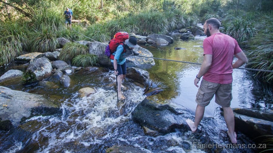
Crossing the Knysna River was both quite fun, and challenging. You cross the river with a rope, going from one slippery rock to the next. With your backpack on your back, it is tricky to keep your balance on the slippery rocks, and hold on to the rope as well.

Just when you think you have really had enough, the hut suddenly appears in a clearing in the forest. We were just in time at the hut, before the rain started pouring down. It was a long day, and we were quite exhausted. Socks and boots were wet and placed outside to dry. No electricity or hot showers here.


Day 3: Rondebossie to Diepwalle Hut: 13 km
On day 3 we kicked off with a lovely walk in the rain that was drizzling down. We backtracked through the forest for a while on the route that we have arrived in the previous afternoon, and then the trail leads out of the forest into beautiful fynbos, where we saw proteas and other indigenous fynbos plants in bloom. Simply beautiful and an awesome experience. There is an abundance of wild flowers in bloom everywhere.


We took the time for some taking photos once we were on the contour path. It was still rainy, and we had our raingear handy. But the cool weather and the beautiful flowers lifted our spirits and we had a lot of fun. Our group members were all simply amazing.


Then a hill awaits you and after that another HILL. The top offers a spectacular view though and we had a little break here. The rest of the route is an easy cruising through the beautiful forest. Larger than life ferns tower above your head, and you feel like “Alice in wonderland”, and fairies awaits under ever fern.


We could not wait to reach the Diepwalle hut where electricity and a warm shower awaits you. Diepwalle hut is also next to the Diepwalle Tea Garden, and surely not to be missed.


We got hold of the tea garden’s telephone number before the hike, and they provided us with their menu. It is also available in the Rondebossie Hut. I got all the orders for our group members at Harkerville already, and send a What’s-App message to Diepwalle Tea Garden. (We have also shared this information with the hikers from the other two groups that were with us on the trail, and they have pre ordered meals too.) Whilst waiting for the food, we had a nice rest outside, with our feet up. There is cell phone reception too.


What a nice treat to have “take away foods” on you third day of hiking, when you are eating only pastas, and other light weight food. The meals were really prepared upon our arrival, and were served warm and fresh. The personnel there are very friendly and professional. The food was of outstanding quality too. The meals and desert afterwards were the highlight of the hike.


The huts have beautiful views of the surrounding mountains and scenic landscape. Diepwalle has an interesting history, and there is a campsite too.
Day 4: Diepwalle to Fisantehoek Hut 16.5 km:
Other hiking trails criss-cross route near the start, and make sure that you follow the correct trail. It leads through beautiful forest plantations again. We stopped for a break at the large Californian Red Oak trees, that was beautiful and majestic. We had crossed two rivers which offer refreshing resting spots.


We had reached the hut at about 15:30 that afternoon. A beautiful old house and a dam/reservoir with lovely views to the surrounding mountains. – No electricity or hot showers here as well.


DAY 5: Fisantehoek to Harkerville Hut 12 km:
The last day has the shortest distance, 12km, on the trail and the easiest. The trail runs through the forest, and on dirt roads in the forest. You can even take off your back pack from your weary shoulders and stroll through the Garden of Eden as the trail crosses the N2 national road nearby. Be careful when crossing the N2, as it is a very busy road. After that it’s just 5km to the Harkerville hut which boasts electricity and hot water to soothe your weary body. There are a few “slippery when wet” wooden bridges to cross along the way. Be careful not to slip.


We end up back at Harkerville hut very mid-day, and after hot showers, we went to explore the area, and had a proper meal for lunch at Plettenberg bay.


We headed back to Harkerville hut, to refill and repack backpacks, as we would continue with day 6 and 7 the next morning on the Harkerville Coastal circuit trail. See the hike report on that. We did this trail from the 6th to the 10th of August 2022.

There are different options and circular routes available for the Outeniqua hike.
Vehicles are not allowed at all the huts. We left our vehicles safely at Harkerville hut, where there is a reception office of the Garden Route National Park, SANPARKS.
Shuttle can be arranged with: Sharon at Trail Transfers (+27) 82 325 5620
For reservations contact SANPARKS on 044 302 5606 or visit their official website: sanparks.org. Prices may increase annually.
For Diepwalle Tea Garden contact:044 3829762(+27)- international dialling code for ZA
Rating: Difficulty: Easy – Difficult: 8/10—be fit- you carry a backpack for 5/7 days without tents. Beauty: 4/5
Tips for the hike:
Best time to hike: March to October. Fanie and I love to hike during Augst/September, when the weather conditions are ideal for hiking.
Weather can change rapidly, be prepared. Take clothing for heat/cold/rain and also extra rations in case of emergency. A first aid kit is essential. Cell Phone Reception at Millwood, and Diepwalle Huts
Please do not litter or disturb plant life. Also take caution when preparing food at the overnight huts that you use your gas stove in a safe place so as not to cause fires. If you smoke, please ensure that your cigarette butts are properly extinguished.
Take many pictures and memories, and leave only footprints as you enjoy this incredible hike.
Distances:
Day 1 – Beervlei to Windmeulnek: 16km (Was closed for renovation due to veld fires)
Day 2 – Windmeulnek to Platbos: 17km (Was closed due to veld fires) Check with SANPARKS if it is open again.
Day 3 – Platbos to Millwood: 15.5km- (We started off at the Goudveld parking Area near Platbos- to Milwood)
Day 4 – Millwood to Rondebossie: 17km
Day 5 – Rondebossie to Diepwalle: 13km
Day 6 – Diepwalle to Fisantehoek: 16.5km
Day 7 – Fisantehoek to Harkerville: 12km
Route Markers: Black signs with white boot prints in.
Parking Spots & Start/End Points:
Harkerville Hut: S34 02 881 E23 14.085
Other: The water in the streams is consumable, the dark tea like colour is due to the tannins and humic acids from the leaves on the forest floor. No need for purifying tablets, drops or filters.
This hike is regarded as one of the gems of the Garden Route, and under the top 10 most scenic in S.A. It is, however not for the unfit, weak or faint hearted. A certain level of fitness is required as the total distance of the trail is 108km. You will carry a full kit without a tent, and your back pack will be heavy. You are advised to wear a good pair of boots with thick socks.
Your feet might hurt (and some other spots too) and the days can be quite challenging. You will however, be rewarded with unsurpassed beautiful landscape and scenery of the famous Outeniqua Mountains and forests.
Take a fitted sheet for a single bed, Matrasses are covered, but covers were deteriorated.
Foot note:
The products/ food/ gear that are referred to, are things that we personally prefer to use, or helped us on our hiking expeditions, since we have started hiking. Personal preferences may vary from one hiker to the next, regarding gear, food and products used.
All information given above, is based on our personal experience, circumstances, observations and weather conditions of a certain hike.
It might differ from other hikers’ experiences, or different weather conditions and circumstances.